Pioneering Drone Journalism After Typhoon Haiyan in Tacloban
In November 2013, Lewis Whyld travelled to Tacloban in the Philippines following Super Typhoon Haiyan, carrying a custom-built camera drone in a cabin-sized case. At a time before drones were established as professional newsgathering tools, Lewis used the aircraft to document the scale of destruction from above, reaching areas that were inaccessible from the ground and providing aerial footage for CNN’s international coverage. The images were broadcast around the world and became an early landmark in mainstream drone journalism. CNN published the aerial report on 18 November 2013, describing how the drone revealed the dramatic scale of devastation across Tacloban. It was the first major news story documented with a drone and became a defining moment in the use of the technology.
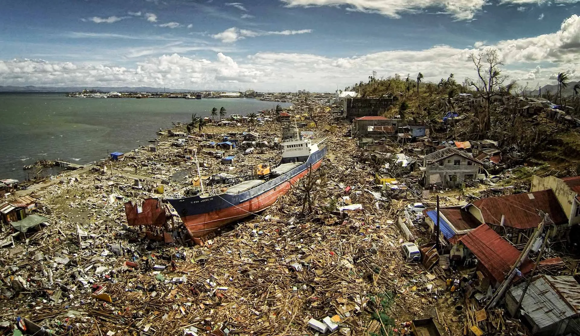
Drone footage filmed by Lewis Whyld over Tacloban following Typhoon Haiyan in November 2013. The custom-built aircraft was used to document areas inaccessible from the ground, revealing the scale of destruction for CNN’s international coverage and demonstrating the potential of drones as serious tools for breaking-news journalism.
Project Details
Broadcaster: CNN
Additional Publisher: The Telegraph
Location: Tacloban, Leyte, Philippines
Date: November 2013, with a return assignment approximately six months later in May 2014
Role: Photojournalist, Drone Pilot & Drone Camera-System Designer - Lewis Whyld
Story: Super Typhoon Haiyan / Yolanda
Filming: Custom-built aerial drone cinematography and ground-based visual journalism
Aircraft: Self-built quadcopter configured with a camera gimbal for stable, broadcast-quality aerial footage
Design Requirement: Aircraft and supporting equipment packed into a cabin-sized case for rapid international deployment
Operating Environment: Major natural-disaster zone with widespread destruction, disrupted infrastructure, limited power, food and water, and severely restricted ground access
Coverage: Aerial documentation of Tacloban and surrounding areas devastated by the typhoon
Journalistic Use: Showing the overall scale of the disaster and reaching areas inaccessible to journalists and emergency responders on foot
Humanitarian Relevance: The aerial flights revealed victims in areas that had not yet been reached; contemporary reporting states that two bodies seen during the flights were subsequently recovered.
Return Assignment: Six months later Lewis returned to Tacloban and manually recreated the original drone routes to produce direct aerial comparisons of destruction and recovery
Recognition: CNN’s Typhoon Haiyan coverage won the Royal Television Society award for News Coverage - International
Emmy Recognition: CNN’s coverage received a 35th Annual News & Documentary Emmy nomination for Outstanding Live Coverage of a Current News Story
Specialism: Disaster Journalism / Drone Cinematography / Broadcast / Custom Aircraft Engineering / Hostile & Remote Environments / Breaking News
CNN Project: CNN’s original 2013 aerial report from Tacloban. CNN — Drone Camera Aerial View of Tacloban
Telegraph Follow-Up: Six-month aerial comparison of Tacloban’s recovery. The Telegraph - Typhoon Haiyan: Tacloban Six Months On
Historical Significance: First mainstream drone journalism on a major news story and earliest documented professional FPV flythrough used on a major international breaking-news assignment
Building a Drone for Breaking-News Journalism
Lewis had begun experimenting with small aerial camera systems in 2011, looking for a way to carry an aerial platform into disasters and breaking-news assignments without relying on helicopters or military aircraft. His early experiments included fixed-wing aircraft, but the footage was too unstable for professional use.
As Haiyan approached the Philippines in 2013, Lewis completed a new quadcopter system and added a gimbal capable of producing smooth footage suitable for television. The complete system was designed around deployment as much as image quality: it could be packed into a cabin-sized case and carried onto an international flight at short notice.
When Lewis reached Tacloban, communications and infrastructure had been devastated. His pitch to CNN was simple: “I’ve got a helicopter in my briefcase.” CNN agreed to incorporate the drone into its reporting, allowing the camera to move above wrecked neighbourhoods and across routes that were impossible to cover effectively from ground level.
This was years before compact cinematic drones became routine production equipment. The engineering challenge was therefore inseparable from the journalism: if an aerial perspective was required, Lewis had to design, build, transport and operate the camera platform himself.
Using a Drone to Reach Areas Inaccessible from the Ground
The purpose of the flights was not simply to produce dramatic aerial photography. Tacloban contained extensive areas that could not easily be reached because roads and neighbourhoods had been destroyed or blocked by debris.
Contemporary reporting in The New York Times, subsequently reproduced and discussed by other publications, described how Lewis’s drone showed the overall scale of the destruction and located two bodies in areas that had not yet been reached; they were later recovered by the authorities. Press Gazette highlighted the work days later in an article titled “Drone journalism enters the mainstream”.
Columbia Journalism Review later used Lewis’s work in Tacloban as a major example of what aerial journalism could do differently, noting that the aircraft could fly across impassable roads and into places conventional crews could not reach. Lewis told CJR that the point was not simply aerial aesthetics but gaining access to parts of a disaster zone that were otherwise impossible to document.
That distinction is important to this case study: the drone was being used as a journalistic access tool, not merely as an alternative camera angle.
A Milestone in Mainstream Drone Journalism
The Haiyan footage quickly became part of the wider discussion about how unmanned aircraft could change news reporting.
Press Gazette described Lewis’s Tacloban coverage in an article specifically examining how drone journalism was entering the mainstream, while contemporary international reporting based on The New York Times highlighted both the CNN broadcasts and the discovery of victims from the air.
The Center for the Study of the Drone at Bard College subsequently cited the Tacloban flights in its overview of early drone journalism, noting that Lewis flew across areas inaccessible on foot before returning six months later to document recovery.
The significance extended beyond journalism. A United Nations OCHA report on unmanned aerial vehicles in humanitarian response used Lewis’s return to Tacloban as an example of how UAV imagery could communicate the scale of a disaster and assess recovery. The World Bank likewise singled out his work, describing him as one of the first journalists to reach Tacloban and highlighting the value of his aerial imagery both immediately after the storm and during the later recovery.
An Early Professional FPV Flythrough on a Major News Story
During CNN’s coverage of Typhoon Haiyan in Tacloban in November 2013, Lewis Whyld used FPV to fly directly through a destroyed building, moving the camera through the structure rather than simply filming it from outside.
The sequence was created for a major international breaking-news assignment at a time when professional FPV cinematography was barely established.
That makes the Tacloban sequence one of the earliest documented professional FPV building flythroughs used in broadcast journalism, and the first used on a major breaking-news assignment.
The flight demonstrated that a small self-built aircraft could do more than provide conventional aerial views. It could move through damaged structures and spaces that were unsafe or difficult for a camera operator to enter, giving viewers a continuous first-person perspective of the destruction.
Shot in November 2013, the sequence predates the widespread adoption of cinematic FPV flythroughs in commercial, film and television production by many years and forms part of Lewis Whyld’s early work developing drones as practical tools for visual journalism.
Returning to Tacloban Six Months Later
Lewis returned to Tacloban approximately six months after the disaster for The Telegraph, using the original footage as a reference and manually flying the drone back over the same routes.
The return assignment involved around 10 days of work and approximately 20 hours of flight time. By recreating the original movements from November 2013, the footage produced direct aerial comparisons between the immediate aftermath of Haiyan and the state of Tacloban during reconstruction.
The comparisons showed significant debris clearance and the return of infrastructure, but also highlighted slower progress in housing. Areas near the coast that had been devastated were being occupied again because many residents had limited alternatives. The World Bank later cited the project as an example of visual technology being used to provide accountability during long-term disaster recovery.
That makes the second Tacloban assignment important in its own right: the drone was no longer only documenting a breaking event. It had become a repeatable visual measurement tool capable of showing change over time from the same aerial perspective.
Awards & Recognition
CNN’s coverage of Typhoon Haiyan received major industry recognition, with Lewis Whyld’s pioneering drone footage from Tacloban forming part of the wider reporting.
Royal Television Society:Winner — News Coverage: International, CNN Coverage of Typhoon Haiyan. The award recognised CNN’s reporting from the disaster zone under exceptionally difficult conditions.
News & Documentary Emmy Awards:Nominee — Outstanding Live Coverage of a Current News Story, CNN Newsroom: CNN’s Coverage of Typhoon Haiyan, at the 35th Annual News & Documentary Emmy Awards.
Lewis Whyld: Drone Pilot, Photojournalist & Camera-System Designer — contributor to CNN’s award-winning and Emmy-nominated Typhoon Haiyan coverage.
The Tacloban drone work also attracted significant international attention in its own right. The New York Times reported directly on Lewis Whyld’s use of a drone after Typhoon Haiyan, including its ability to document areas that were inaccessible from the ground and locate victims who were later recovered. The assignment was subsequently cited by Press Gazette as an example of “drone journalism entering the mainstream”, while Columbia Journalism Review highlighted it as an early demonstration of how small unmanned aircraft could expand journalistic access in disaster zones.
The work also entered the wider discussion around humanitarian and disaster-response use of drones. The World Bank later referenced Lewis Whyld’s Tacloban footage as an example of aerial imagery being used to document destruction and recovery, while UN OCHA cited the use of UAV imagery after Haiyan in its analysis of humanitarian response and disaster assessment.
RTS Award:CNN Coverage of Typhoon Haiyan — News Coverage: International
CNN Emmy Announcement:CNN Honored with 11 News & Documentary Emmy Nominations
The New York Times:Report on Lewis Whyld’s drone journalism in Tacloban following Typhoon Haiyan
Industry Recognition:Press Gazette — Drone Journalism Enters the Mainstream
Further Context:Columbia Journalism Review — Eye in the Sky
World Bank:Philippines: Drones and Spreadsheets to the Rescue
South China Morning Post:Drone photography develops new frontier in journalism
New York Times / sUAS News:Drones Offer Journalists a Wider View — contemporary coverage of Lewis Whyld’s pioneering drone work in Tacloban, including CNN broadcast use and the discovery of victims from the air.
NPR:Video: An Aerial View of the Damage in Tacloban — contemporary coverage of CNN’s drone footage showing the devastation after Typhoon Haiyan. NPR — An Aerial View of the Damage in Tacloban
Related Case Studies
Ukraine for CNN — Emmy-winning FPV and conventional drone cinematography in an active conflict environment.
Iceland Volcano for CNN — Specialist FPV filming inside an active volcanic eruption using a custom-built Moonshot platform.
Chernobyl Reactor 4 — Drone and immersive 360° filming inside the Chernobyl Exclusion Zone under radiation-controlled conditions.
Greenland — Global Warning: Arctic Melt — Emmy-nominated and multi-award-winning aerial cinematography across glaciers, wildlife and extreme Arctic environments.
Nepal Earthquake — Disaster-zone aerial filming following another major humanitarian emergency.
Explore All FPV & Drone Case Studies →
Specialist Drone Cinematography for Breaking News & Extreme Environments
The Tacloban assignment established an approach Lewis Whyld has continued throughout his career: combining visual journalism with the ability to design and adapt camera systems around environments where conventional production methods cannot provide the required access.
Since Typhoon Haiyan, that work has expanded from early custom-built news drones into FPV, long-range aerial platforms, immersive 360° systems and specialist aircraft designed for extreme environments.
From disaster zones and active conflict to Arctic expeditions, nuclear sites and volcanic eruptions, the objective remains the same: use the aircraft because it provides a perspective or access that genuinely contributes to the story.